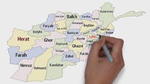
Afghanistan, shares borders with Pakistan to the east and south, Iran to the west, Turkmenistan, Uzbekistan, and Tajikistan to the north, and China to the far northeast via the Wakhan Corridor. Encompassing 652,867 km2, its terrain is predominantly mountainous, dominated by the mighty Hindu Kush range, which separates the fertile northern plains from the southwestern deserts. With an estimated population is more than 43 million, the country is a tapestry of ethnicities and cultures. This guide provides an exhaustive, detailed exploration of its most significant provinces and their key attractions, focusing on precise data, historical events, and the figures who shaped them.
Kabul Province: The Layered Capital
- Provincial Capital: Kabul City (also the national capital).
- Location: (East-Central)
- Coordinates: approximately 34.5553° N, 69.2075° E
- Time Zone: GMT +4:30 (Afghanistan Standard Time).
- Climate: Cold semi-arid climate
- Altitude: Precisely 1,797 meters (5,896 feet) above sea level.
- Area: 275km2
- Population: More than 4.5 million inhabitants, making it Afghanistan’s largest urban center.
- Ethnic Group: Multi-ethnic (Pashtun, Tajik, Hazara, Uzbek, others)
- Historical Significance: Kabul’s history spans more than 3,500 years. It was mentioned during the Achaemenid Persian Empire (c. 550–330 BC) and served as a key hub on the ancient Silk Road. It has been the capital of Afghanistan since 1776. Over millennia, it has been controlled by a succession of empires including the Seleucids, Kushans, Samanids, Ghaznavids, Timurids, Mughals, and later the British (during the Anglo-Afghan Wars).
Key Attractions of Kabul:
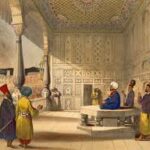
- The Blue Mosque (Sakhi Shrine)
The Blue Mosque is a major shrine in Kabul, located at the foot of Television Hill. It is sacred because it marks a spot associated with the cloak of Prophet Muhammad and a visit from Ali, his cousin and son-in-law.
According to tradition, Muhammad’s cloak was moved across the Islamic world for centuries. In 1767/1768 CE, Ahmad Shah Durrani ordered it moved to Kandahar. The first single-domed structure funded by Ahmad Shah. The cloak stayed for eight months there before continuing to Kandahar, where it remains. The shrine was expanded over time: a second dome was added in 1919 by the mother of King Amanullah Khan, and four more domes were added during a major renovation between 2008 and 2016.
- Bagh-e Babur (Babur’s Garden):
These terraced gardens represent the zenith of Mughal landscape architecture in Afghanistan and the personal passion of an emperor.
- Origin and Founder: The gardens were originally laid out in the mid-16th century by Zahir-ud-din Muhammad Babur (1483–1530), the founder of the Mughal Empire, after he captured Kabul in 1504. He used the gardens as a summer retreat and guesthouse.
Later Additions:
- Summer Pavilion: 19th century
- Shah Jahan’s Marble Mosque: It was built in 1646 by the Mughal Emperor Shah Jahan (of Taj Mahal fame) specifically to commemorate his military capture of Balkh. This mosque was meticulously restored between 1964 and 1966 by a team of Italian archaeologists and architects led by B.C. Bono.
- The Tomb of Babur: The garden’s spiritual core is the modest tomb of Emperor Babur. He died in Agra, India, in 1530, but in his memoirs expressed a deep desire to be buried in Kabul. Due to political instability, his body was initially interred in Agra. It was his loyal Afghan wife, Bibi Mubarika Yusufzai, who eventually orchestrated the transfer of his remains to Kabul, fulfilling his wish years after his death. Initially, per his instructions, his grave was left open to the sky. Later, during the reign of King Nadir Shah, a marble slab and a protective pavilion were erected. The inscribed headstone dates from the era of Mughal Emperor Jahangir (early 17th century). The tomb is surrounded by those of family members: his son Mirza Hindal, a grandson Mohammad Hakim Mirza, a daughter Nawab Gawhar Nisa Begum, and a granddaughter Roqia Sultan Begum.
- Shah-Do Shamshira Mosque:
This distinctive two-story, yellow-colored mosque is a 20th-century landmark with deeper historical roots.
- Location: It stands on the left bank of the Kabul River, directly across from the Mausoleum of Timur Shah Durrani.
- History: The site has held a mosque since 1544. The current, ornate structure was commissioned in the early 1920s by Queen Soraya Tarzi, the wife of King Amanullah Khan and a key modernizing figure. The small tomb beside that mosque is believed to belong to an early Arab Muslim commander from the 7th century. He is known locally as Sha-e-Do Shamshira, meaning “The Two-Sworded King,” a title linked to the legend that he fought with two swords during the early spread of Islam in Kabul. He was killed in battle, and his burial here dates to around 680-700 CE. Over time, the site became a respected local shrine connected to the arrival of Islam in Kabul. Some sources suggest that it is the tomb of Chin Timur Khan, a Mughal general and a cousin of Emperor Babur. he died in the early 16th century.
- Kabul Bala Hisar Fort:
This fortress is a sentinel of Kabul’s military history, towering 150 feet (45 meters) above the surrounding plain.
- Origins: Archaeological evidence dates its earliest foundations to the 5th century AD, during the period of the Hephthalite (White Hun) Empire. It was continuously fortified and repaired by subsequent dynasties, including the Ghaznavids, Ghurids, and Mughals, through the 18th century.
Key Historical Events:
- Mughal Era: The fort served as a primary residence for Emperor Babur in the early 16th century.
- Second Anglo-Afghan War: On September 3, 1879, the British envoy Sir Louis Cavagnari and his entire escort were massacred inside a palace on the fort’s southern side. In retaliation, a British force under General Roberts occupied Kabul, stormed the BalaHisar, executed the rebels, and systematically destroyed the interior palaces in the spring of 1880.
- Id Gah Mosque:
This is Kabul’s primary congregational mosque for major Islamic festivals, most notably Id-ul-Fitr.
- Founder and Construction: The mosque was a project of Amir Abdur Rahman Khan, 1893-94 AD, construction was completed in 1897-98 AD.
- Architectural Specifications: The scale is immense. The prayer hall measures 146 meters (480 feet) in length and 44 meters (144 feet) in width. The roof is supported by rows of pillars and features 76 small domes, with a larger central dome soaring 12 meters (40 feet) above a 10×10 meter square chamber. The ornate semi-dome over the entrance portal is decorated with intricate molded stucco featuring floral designs and ribbed coronets, a signature style of Abdur Rahman’s era.
- National Museum of Afghanistan:
Located on Darulaman Avenue, this institution is the guardian of the nation’s millennia-spanning heritage.
- History: It was officially inaugurated in 1919. By the 1970s, its collection—which included the famed Bactrian Gold, Greco-Buddhist artifacts from Hadda, and frescoes from Bamiyan—was considered one of the most important in Asia.
- Tragedy and Resilience: During the civil war of the 1990s, the museum was directly shelled, and approximately 70% of its 100,000+ artifacts were looted or destroyed. A heroic effort by staff hid key pieces. Since 2001, international efforts have aided in recovery, restoration, and the return of looted items.
- Darul Aman Palace:
Situated at the end of Darulaman Avenue opposite the museum, this palace is a symbol of thwarted modernization.
- Construction: It was built in the Neoclassical style in 1923 by King Amanullah Khan (ruled 1919–1929), who envisioned it as the centerpiece of a new, modern capital district separate from old Kabul.
- Fate: It never served its intended purpose as a parliament. It was damaged by fire in 1969, became a ruin during the civil war, and has survived as a stark, iconic shell.
Tajbeg Palace
Tajbeg Palace, sometimes called the Queen’s Palace, is a landmark in the Darulaman district, about 16 km from Kabul’s center. It was constructed in the 1920s as part of King Amanullah Khan’s project to modernize Afghanistan and originally housed the royal family.
After the Soviet withdrawal, the palace was severely damaged during the civil wars of the 1990s as mujahideen factions fought for control of Kabul. The palace was completely rebuilt and restored by 2021.
Wazir Akbar Khan Hill
It is recognized as a major cultural and tourist spot and has been used for public ceremonies. In September 2014, a monumental flagpole about 207 feet (63 meters) tall, along with a very large Afghan national flag measuring roughly 60 by 90 feet, was installed on the hill as a gift from the Flag Foundation of India, symbolizing friendship between the two countries. Following political changes in Afghanistan, the original national flag was replaced in 2022 with a large white flag bearing the Islamic profession of faith, raised by the Taliban-led government.
Television Hill (Koh Asamai) :
Koh-e Asamai, often called Television Hill, is a mountain in Kabul with an elevation of 2,126 metres. Its summit has a large TV mast. The mountain is named for an ancient Hindu temple at its base, a very important site for Afghan Hindus. The temple is dedicated to the Goddess of Hope, Asha Mai. A smaller, original temple site remains at the mountain’s peak. Ehsan Bayat funded the temple’s renovation in 2006.
- The Bird Market & Environs:
For a glimpse of traditional Kabul life, the Bird Market (Ka Foroshi) is a narrow alley in the old city where shopkeepers sell birds—especially prized fighting partridges—in beautifully handcrafted wooden cages. Nearby, the Old British Cemetery contains graves from the Second Anglo-Afghan War (1878-80).
Chicken Street:
Chicken Street is a famous narrow shopping street in Kabul’s Shahr-e Naw area. From the 1960s to late 1970s, it was a major attraction for foreigners and hippies, who bought Afghan coats, handicrafts, and souvenirs. Tourism declined after the Soviet–Afghan War began. After 2021, an improvement in security led to a new spike in tourists, and Chicken Street regained its attraction. Despite its name, chickens are not sold here—they are sold on nearby Flower Street. Chicken Street was the subject of a 2005 novel by Amanda Sthers and appeared in the 2007 documentary 16 Days in Afghanistan.
- Istalif:
A town located 45 kilometers north of Kabul, historically famous for its unique turquoise-glazed pottery. Nestled in the hills with vineyards and orchards, it was a favorite retreat of Emperor Babur, who wrote fondly of its beauty.
Bamyan Province: Valley of the Giants
- Provincial Capital: Bamyan City.
- Location: (Central)
- Coordinates: approximately 34.8216° N, 67.8273° E
- Time Zone: GMT +4:30 (Afghanistan Standard Time).
- Altitude: 2,500 meters (8,203 feet)—a high, cold desert valley.
- Climate: Cold semi-arid climate
- Area: 35km2
- Population: The city has an estimated population of nearly 500,000, making it the largest in the central Hazarajat region.
- Ethnic Group: Predominantly Hazara
- Geography: A broad, fertile valley flanked by the towering cliffs of the Koh-i-Baba range, a western extension of the Hindu Kush.
Key Attractions of Bamyan:
- The Buddha Statues (Historical Site):
These were not just statues but the spiritual center of a vast monastic complex that thrived for centuries.
Construction and Specifications:
- The Smaller Buddha: Carved first, likely in the late 3rd or early 4th century AD. Its exact height was confirmed by later surveys to be 38 meters (125 feet). The technique involved carving the general shape from the living sandstone cliff, then coating it with a mixture of mud and straw for modeling details. A final layer of fine gypsum plaster (gatch) was applied and painted. Traces of dark blue paint were found on the robe, and yellow on the neck, indicating the face and hands were likely gilded.
- The Larger Buddha: Created later, in the 6th century AD, standing 55 meters (180 feet) tall. Its drapery was formed by a different method: ropes were draped over the carved rock to create the folds of the robe, then covered in the mud-straw-plaster mix. The series of small, square holes visible in the niche are from the wooden pegs that secured these ropes. This statue was painted crimson red, with gilded hands and face.
- Historical Accounts: The Chinese Buddhist pilgrim Hsuan-tsang (Xuanzang) provided a detailed eyewitness account after visiting in 632 AD. He described the larger Buddha as shining with “golden hues” and recorded the presence of “ten monasteries and more than a thousand priests” in the valley, most living in caves between the two colossi.
- Modern Preservation and Tragedy: From 1969 to 1979, a major preservation project was undertaken by the Archaeological Survey of India, led by Director R. Sengupta, in collaboration with the Afghan Institute of Archaeology. Work included cleaning, crack-filling, embedding steel reinforcement rods into the crumbling cliff, and installing a drainage system at the top to divert water. Earlier, in the 1920s and 1930s, French archaeologists from DAFA (Délégation Archéologique Française en Afghanistan) had cleaned centuries of thick soot from nomad campfires off the cave wall paintings. The statues were tragically destroyed by dynamite in March 2001 by the Taliban.
- Band-e-Amir National Park:
Afghanistan’s first national park, established by presidential decree in 2009 (though first proposed in 1973), is a geological wonder.
- Formation: The six lakes are dammed by natural travertine (mineral) deposits formed as calcium-carbonate-saturated water from springs precipitates out. This process continues, slowly raising the dams.
The Lakes in Detail:
- Band-e-Zulfiqar (Dam of Ali’s Sword): The largest lake, approximately 6.5 kilometers (4 miles) long.
- Band-e-Haibat (Dam of Awe): The most accessible and iconic lake, with a travertine dam 12 meters (40 feet) high. A small shrine called Qadamgah is built here, believed to mark a place where Hazrat Ali, the fourth Caliph and first Shia Imam, stood. The mineral-rich water is considered by pilgrims to have healing properties.
- Band-e-Ghulaman (Dam of the Slaves): Roughly 1.2 kilometers (0.75 miles) in diameter.
- Band-e-Panir (Dam of Cheese): A small, circular lake about 150 meters (yards) across.
- Band-e-Pudina (Dam of Mint): Another small lake.
- Band-e-Kambar (The Groom’s Dam): Often dry or marshy.
- Shahr-e Zohak (The Red City):
This fortress complex guards the eastern entrance to the Bamyan Valley where the Bamyan and Kalu rivers meet.
- Strategic History: The site has been fortified since at least the B.C. era. It was significantly expanded by the Hephthalite Huns in the 6th century AD. The most prominent surviving ruins date from the Shansabani (Ghurid) dynasty in the 12th-13th centuries AD.
- The Mongol Siege: In 1221 AD, the fortress withstood an assault by a Mongol army commanded by Mütügen, the favorite grandson of Genghis Khan. During the fighting on the plain below, Mütügen was mortally wounded. Enraged, Genghis Khan vowed vengeance and subsequently laid waste to the entire Bamyan Valley, killing every
- Architectural Layout: The fortress is entered via the original steep pathway. Guard towers along the path have no ground-level doors; defenders used ladders pulled up behind them. Inside, massive, round “pumpkin-ribbed” towers protect a gateway leading to the main barracks, which could house a garrison of 500 soldiers in peacetime and 2,000-3,000 in wartime.
- Gholghula City (Shahr-e-Gholghula): The Silent Capital of Medieval Bamyan
Gholghula City is one of the most important medieval archaeological sites in central Afghanistan and represents the former urban and administrative heart of the Bamyan Valley before its total destruction in the early 13th century.
- Location: Approximately 2 kilometers southwest of modern Bamyan City, overlooking the central valley floor.
- Area: The fortified city occupies a rocky hilltop covering an estimated several hectares, with steep slopes providing natural defense on all sides.
- Origins: Archaeological evidence suggests the site was inhabited as early as the 6th century AD, with major expansion between the 9th and 12th centuries during Islamic rule.
- Political Role: Gholghula functioned as the main administrative and residential city of Bamyan, while nearby sites such as the Buddha niches and monastic caves served religious purposes.
- Population Capacity: Based on housing density, water systems, and food storage remains, scholars estimate the city could have supported several thousand inhabitants, including civilians, soldiers, and officials.
Defensive Architecture and City Layout:
- City Walls: Remains of thick mud-brick and stone fortification walls, originally reaching heights of up to 8–10 meters, encircled the settlement.
- Watchtowers: Multiple semi-circular and rectangular towers were positioned at strategic points, allowing surveillance across the valley and control of caravan routes.
- Internal Structure: The city contained residential quarters, administrative buildings, storage rooms, narrow streets, stairways, and a complex water-management system using channels carved into rock to collect and distribute snowmelt.
The Mongol Destruction (1221 AD):
- Event: In 1221 AD, Gholghula City was besieged by Mongol forces under Genghis Khan during his Central Asian campaign.
- Trigger: According to historical sources, the Mongol assault intensified after the death of Mutugen, Genghis Khan’s favored grandson, who was killed during fighting in the Bamyan region.
- Outcome: The city was completely annihilated. Contemporary accounts describe the massacre of the population and the deliberate destruction of buildings.
- Name Origin: The name Gholghula is traditionally translated as “City of Screams,” reflecting oral histories of the destruction and mass killing.
Herat Province: The Timurid Jewel
- Provincial Capital: Herat City.
- Location: (West)
- Coordinates: approximately 34.3529° N, 62.2040° E
- Altitude: 920 meters (3,020 feet).
- Time Zone: GMT +4:30 (Afghanistan Standard Time).
- Climate: Dry hot summers and cold winters
- Area: 182km2
- Population: Over 752,910, making it Afghanistan’s third-largest city.
- Ethnic Group: Predominantly (with Tajik, Pashtun, Hazara, others)
- Historical Role: A premier Silk Road oasis for over 2,000 years, renowned as a center for Persian arts, literature, and science, particularly during the Timurid Renaissance (15th century).
Key Attractions of Herat:
- Friday Mosque (Masjid-i Jami):
This is not a single-era construction but an architectural palimpsest built, destroyed, and rebuilt over eight centuries.
- Origins: The first mosque on the site was built by the Ghurid dynasty in 1200 AD. It was destroyed by Genghis Khan’s armies in 1221.
- Timurid Reconstruction: The mosque was magnificently rebuilt starting in 1404 AD under Timur (Tamerlane) and his son Shah Rukh, who made Herat his capital. The project continued under Queen Gawhar Shad (wife of Shah Rukh) and later rulers.
- Architectural Detail: The entire courtyard is enveloped in breathtaking mosaic tilework (kashi) and inscribed faience (mosaic of glazed tiles). The dominant colors are lapis lazuli blue, white, and turquoise, forming intricate geometric patterns, floral motifs (islimi), and Kufic and Thuluth calligraphy of Quranic verses. It is rightly considered the finest surviving example of Islamic architecture in Afghanistan.
- The Musalla Complex & Mausoleum of Gawhar Shad:
Once a sprawling theological campus, this complex is a testament to both supreme artistry and catastrophic loss.
- Construction: Commissioned and overseen by Queen Gawhar Shad (c. 1378–1457), the brilliant wife of Timurid ruler Shah Rukh. The complex, including a mosque, madrasa, and her own mausoleum, was built starting in 1417 AD.
- Scale and Destruction: At its peak, it featured 20 minarets and a vast mosque. In 1885, during the Panjdeh Incident (a border dispute between Russia and Britain), British military engineers, fearing the complex could provide cover for a Russian advance on Herat, deliberately demolished most of it with explosives. Only five minarets and the mausoleum were left standing.
- Mausoleum of Gawhar Shad: This surviving structure is a masterpiece. Its ribbed, double-shell dome is clad in brilliant Persian-blue tiles. The high drum (cylinder) beneath the dome is encircled by a 2-meter tall band of white Kufic calligraphy on a royal-blue background, bearing Quranic verses. Tall, arched panels (pishtaqs) flanking the entrance are covered in intricate floral and geometric mosaics. Inside, the muqarnas (stalactite) vaulting, interlacing arches, and multiple domes are adorned with lavish painted decoration: swirling floral motifs (islimi) and bands of elegant calligraphy executed in lapis lazuli pigment (crushed from Badakhshan stone), rust-red, and gold leaf (gilt). In the center of the mausoleum chamber lie the plain marble tombstones of Gawhar Shad, her son Prince Baisunghur (a famed calligrapher and patron, d. 1433), and other descendants. The queen, a formidable political and cultural patron, was murdered at the age of approximately 80 in 1457 during a succession struggle. The remaining minarets, now tilting precariously, are decorated with intricate brickwork patterns, standing as silent, fragile sentinels to a lost grandeur.Tall, arched panels (pishtaqs) are covered in floral mosaics.
- Herat Citadel (Qala Ikhtyaruddin):
This fortress dominates the old city skyline.
- Foundations: Local tradition and some historians assert the first fortifications were laid by Alexander the Great around 330 BC, when the city was known as Artacoana. The current structure’s core dates from the Timurid period (15th century), built upon these ancient foundations.
- Modern History: It served as a key military base until being heavily damaged in the 19th and 20th centuries. A major restoration project, funded internationally, was completed in 2011, and it now houses a museum and cultural center.
- Shrine of Khoja Abdullah Ansari:
Located in the village of Gazargah, just northeast of Herat.
- Subject: The shrine honors Khoja Abdullah Ansari (1006–1088 AD), also known as the Pir-e Herat (Saint of Herat), a revered Sufi mystic, poet, and scholar.
- Structure: The current mausoleum is a Timurid-era construction from the 15th century, featuring a distinctive turquoise dome and intricate tilework. It is a major pilgrimage site.
- The Old City:
Herat retains one of Afghanistan’s most intact medieval urban cores. Its covered bazaars (such as the Chahar Suq), caravanserais, and traditional Herati houses with central courtyards and ornate wooden balconies offer a living historical experience.
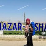
Balkh Province & Mazar-i-Sharif: The Ancient and the Sacred
- Provincial Capital: Mazar-i-Sharif.
- Location: (North)
- Coordinates: approximately 36.7090° N, 67.1109° E
- Altitude: Mazar-i-Sharif: 377 meters; Ancient Balkh ruins: 357 meters.
- Time Zone: GMT +4:30 (Afghanistan Standard Time).
- Climate: Arid, with very hot summers and cold winters.
- Area: 16,186km2
- Population of Mazar-i-Sharif: Estimated between 500,000 and 680,000.
- Ethnic Group: Multi-ethnic (Uzbek, Tajik, Pashtun, Hazara, others)
Key Attractions of Balkh Province and Mazar e Sharif:
- The Blue Mosque (Rawze-e-Sharif, Mausoleum of Ali):
This is the spiritual heart of northern Afghanistan and one of the country’s most venerated sites.
- Legend and History: According to local and Shia tradition, the body of Hazrat Ali ibn Abi Talib (the fourth Caliph and first Imam), who was assassinated in 661 AD in Kufa (Iraq), was secretly brought here to protect it from desecration. A shrine was later built over the purported grave. The site was “rediscovered” in the 12th century by a local mullah following a dream. The current magnificent structure dates primarily from the 15th-century Timurid period, with major restorations in the 19th century by Amir Dost Mohammad Khan and later rulers.
- Architecture: The entire complex is a symphony of blue and white faience mosaic tiles. The central dome is flanked by four smaller domes and four towering minarets. The courtyard is vast, and thousands of white pigeons are fed by pilgrims, adding to the ethereal atmosphere. It is the focal point of the Nowruz (New Year) celebrations, drawing hundreds of thousands of pilgrims.
- The Ancient City of Balkh (Bactra):
Located 20 kilometers west of Mazar-i-Sharif, these sprawling ruins are of one of the world’s oldest cities.
- Antiquity and Religious Significance: Balkh’s origins likely reach back to at least 1500 BC. It is famously associated with the prophet Zoroaster (Zarathustra), who is believed to have lived, preached, and possibly died here sometime between 1000 and 600 BC. It was a major center of the Zoroastrian faith.
- Alexander the Great: The Macedonian conqueror captured Balkh (then Bactra) in 328 BC and used it as his main base for two years (329-327 BC) for campaigns into Central Asia. He married Roxana, a Bactrian nobleman’s daughter, here.
- Buddhist and Islamic Eras: Later, it became a great center of Buddhist learning before its conquest by Arab armies in the 8th century AD. It was known as the “Mother of Cities” (Umm al-Bilad) in the Islamic world.
- Cultural Figures: The city was the birthplace in 1207 AD of Jalal-ud-Din Muhammad Balkhi, known as Rumi, the supreme Persian mystical poet. His family fled the Mongol threat when he was a child, eventually settling in Konya, Turkey.
- Mongol Destruction and Ibn Battuta: The city was utterly annihilated by Genghis Khan’s Mongol army in 1220-21 AD. The destruction was so complete that when the renowned Moroccan traveler Ibn Battuta visited in 1333 AD—over a century later—he described it as “a city in ruins.”
- Key Remains: Visible today are the ruins of the Masjid No Gumbad (Haji Piyadah Mosque). This small, nine-domed mosque dates from the 9th century (c. 850-900 AD) and is considered one of the oldest surviving Islamic buildings in all of Afghanistan. the immense mud-brick fortifications (the Bala Hisar) and the City Wall (Burj e Ayaran), The ruins of the Romi Abbey, Khawja Nasr e Parsa Mosque and Rabia Balkhi’s tomb.
Key Remains:
1: Shrine of Khwaja Abu Nasr Parsa
The Shrine of Khawaja Abu Nasr Parsa is a mausoleum in Balkh, Afghanistan, built for the Naqshbandi religious teacher of the same name. He died in 1461. The mausoleum over his grave was built later by the Timurid general, Mir Mazid Arghun. renovated in the late 16th century.
2: Rabia Balkhi:
Rabia Balkhi, also called Rabia al-Quzdari, was a 10th-century poet. She was the first known female poet to write in Persian, as well as Arabic. She is a semi-legendary figure, mostly remembered for her tragic love story with a slave named Bektash.
3: Ancient Wall of Balkh:
The walls originally ran for around 10 kilometers, circling the city’s fortress, homes, and busy markets to protect them. Their impressive size, sometimes up to 60 feet tall and very thick, clearly shows they were built for defense. While the visible walls date from the Timurid period (14th-15th centuries), they stand on much older foundations, possibly from the time of the Kushans and earlier. The wall itself has seen enormous historical changes, from the Arab conquests to the destructive Mongol invasions and the rise of the Timurid Empire.
From the top, one can enjoy wide views of the surrounding plains and far-off mountains, connecting the present to a deep and layered past.
4: Bala Hisar Balkh:
Evidence suggests a settlement existed here as early as 500 BC, but its recorded history powerfully began when Alexander the Great captured it around 330 BC. Following his conquest, the Bala Hisar became the capital of the Greek province of Bactria, embedding Hellenistic culture into its walls. However, this golden age met a brutal end in 1220 when the Mongols under Genghis Khan completely destroyed Balkh, leaving the Bala Hisar in ruins for nearly two centuries. A quiet end for a citadel that had once been a capital of empires.
- Rumi’s Madrasa:
Rumi Madrasa is a historic Islamic school located in Balkh, and is associated with Jalal al-Din Muhammad Balkhi (Rumi), the renowned 13th-century poet and scholar who was born in Balkh in 1207. The madrasa is believed to be linked to the early intellectual and spiritual environment of the city during Rumi’s time. Over the centuries, the structure suffered serious damage and neglect. In recent years, the madrasa has been rebuilt and restored, aiming to preserve its historical significance and honor Balkh’s role as an important center of Islamic learning and culture.
Kandahar Province: The Durrani Cradle
- Provincial Capital: Kandahar
- Location: (South)
- Coordinates: approximately 31.6289° N, 65.7372° E
- Altitude: 1009m (3310ft)
- Time Zone: GMT +4:30 (Afghanistan Standard Time).
- Climate: Desert climate, with very hot summers and mild winters
- Area: 273.4km2
- Population: 577,128
- Ethnic Group: Predominantly Pashtun
Kandahar is the spiritual and political birthplace of the modern Afghan state, serving as the first capital of the Durrani Empire. This is the most sensitive and conservative province in Afghanistan.
Key Attractions of Kandahar:
- Mausoleum of Ahmad Shah Durrani:
This is the tomb of the founder of Afghanistan.
- Historical Figure: Ahmad Shah Durrani (ruled 1747–1772), was elected as king by a loya jirga (grand council) of Pashtun tribes. He established the Durrani Empire, which became the precursor to the modern state of Afghanistan, earning him the title “Baba” (Father of the Nation).
- The Mausoleum: Located in the center of the old city, it is a domed structure decorated with mirror work and tile. His tomb is surrounded by those of his successors.
- Shrine of the Cloak (Kherqa Sharif):
Perhaps the most sacred Islamic relic in Afghanistan.
- The Relic: It houses the Kherqa, believed to be the cloak (burqa) worn by the Prophet Muhammad. It was brought to Kandahar by Ahmad Shah Durrani in the mid-18th century.
- Significance: The cloak is rarely displayed—historically only during times of great national crisis or to legitimize a new ruler. It is kept in a dedicated shrine adjacent to the Friday Mosque.
- Chil Zena (Forty Steps):
A historic site on the southeastern edge of the city.
- Construction: The steep stone steps were carved into the mountainside on the orders of Emperor Babur’s son Humayun in the early 16th century, leading to a command post at the summit.
- Feature: Along the ascent, various inscriptions were carved, including some attributed to Babur himself. It offers a panoramic view over Kandahar.
- Mausoleum of Mirwais Khan Hotak:
Honors an earlier national hero.
- Historical Figure: Mirwais Khan Hotak (1673–1715) was a tribal leader who led a successful rebellion against the Persian Safavid Empire, establishing an independent Hotak dynasty in Kandahar in 1709.
5. Charsuq Bazaar:
Originally laid out by Ahmad Shah Durrani, the bazaar is designed around four main covered streets that meet at a central square known as the Char Suq, creating a lively crossroads of trade and tradition. 1. Herat Bazaar 2. Kabul Bazaar 3. Shah Bazaar, also called the King’s Bazaar 4. Shikarpur Bazaar.
6. The House of Ahmad Shah Abdali
It once belonged to Ahmad Shah Abdali, the founder of the Durrani Empire and the modern Afghan state. Construction of the house began in 1745 and continued for two years. After Ahmad Shah Abdali’s death, the house remained in the possession of his successors for nearly two centuries. In 2022, after the return of the Taliban to power, the property was sold to the government and officially categorized as a historical heritage site. Recently, the house has been opened to tourists.
Ghazni Province: The City of Treasure
- Altitude: 2,219 meters (7,280 feet).
- Location: (East-Central)
- Coordinates: approximately 33.5451° N, 68.4174° E
- Time Zone: GMT +4:30 (Afghanistan Standard Time)
- Climate: Highland continental, with cold, snowy winters and warm summers
- Area: 22,915km2
- Population: 141,000
- Ethnic Group: Multi-ethnic (Pashtun, Hazara, Tajik)
- Name Origin: From the Persian word Ganj, meaning “treasure.”
History of Ghazni Province:
Ghazni’s historical narrative is one of spectacular ascent and devastating falls:
- Early History: It was a thriving Buddhist center known as Gazaka by the 7th century AD. It resisted the Arab Umayyad advance in 683 AD so fiercely that it was made an example of and razed to the ground in 869 AD by the Saffarid conqueror Yaqub ibn al-Layth al-Saffar.
- The Ghaznavid Golden Age (994-1160 AD): Rebuilt, it became the dazzling capital of the Ghaznavid Empire under rulers like Mahmud of Ghazni (ruled 998–1030). From here, seventeen major campaigns were launched into the Indian subcontinent, bringing back immense wealth in gold, jewels, and slaves. Contemporary accounts describe palaces with “domes of silver”, vast libraries, and a court of unparalleled opulence.
- Downfall: The city was sacked and burned by the Ghurid ruler Alauddin Hussein in 1151 AD, who earned the epithet Jahansuz (“World Burner”). Though it recovered somewhat, it was permanently devastated by Genghis Khan in 1221 AD.
- Strategic Proverb: Due to its location on the key route between Kabul and Kandahar, it has been known for centuries as the “key to the possession of Kabul.”
Key Attractions of Ghazni province:
- The Citadel of Ghazni: A massive 13th-century fortress dominating the city, though largely in ruins.
- Minarets of Ghazni: Two ornate, star-patterned brick minarets built by Sultan Mas’ud III (ruled 1099–1115) and his brother Sultan Bahram Shah (ruled 1118–1152). They once stood at the corners of a vast palace complex and stand about 20 meters tall today.
- Mausoleum of Mahmud of Ghazni: A simple, restored tomb that houses the remains of the empire’s most famous ruler.
- Palace of Sultan Mas‘ud III: Archaeological excavations have revealed the elaborate courtyard plan of this Ghaznavid palace.
Badakhshan Province: The Roof of Afghanistan
- Provincial Capital: Faizabad
- Location: (North-East)
- Coordinates: approximately 36.7348° N, 70.8110° E
- Time Zone: GMT +4:30 (Afghanistan Standard Time)
- Climate: High Altitude continental climate with significant temperature swings; summers are generally mild in valleys but winters are severe and snowy.
- Area: 44,059km2
- Population: 1.1 million in 2023
- Ethnic Group: Predominantly Tajiks (Including Pamiri groups), also Kyrgyz, and Uzbek
- Geography: A remote, mountainous province in the northeast, containing some of the highest peaks in the Hindu Kush (over 7,000 meters).
- Unique Feature: It includes the Wakhan Corridor, a narrow 350-kilometer long panhandle created as a buffer zone between the British and Russian Empires in the late 19th century.
Key Attractions of Badakhshan province:
- Wakhan National Park:
Established in 2014, this park covers over 1 million hectares.
- Wildlife: It is a critical habitat for endangered species including the Snow Leopard (Panthera uncia), the Marco Polo Sheep (Ovis ammon polii)—known for their massive, curling horns—and the Siberian Ibex.
- Human Culture: The park is home to the Wakhi people, who live in stone houses and practice subsistence agriculture, and a small community of Kyrgyz nomads who herd yaks on the high-altitude plateaus. Their traditional lifestyle remains largely intact.
Nuristan Province
- Time Zone: GMT +4:30 (Afghanistan Standard Time)
- Location: (East)
- Coordinates: approximately 35.3250° N, 70.9071° E
- Climate: Highland, varies with altitude; more precipitation than much of Afghanitan
- Area: 9,225km2
- Ethnic Group: Nuristani (Kata, Ashkun, Kam, Satra, Wasi)
- Name Meaning: “Land of Light” (from Nur). It was known as Kafiristan (“Land of the Infidels”) until its forced conversion to Islam in 1895-96 by Amir Abdur Rahman Khan.
- Unique Culture: The Nuristanis have a distinct Indo-European language and cultural traditions, including intricate woodcarving and polytheistic pre-Islamic beliefs that survived in isolation for centuries. It is one of Afghanistan’s least populated and most inaccessible provinces.
Panjshir Province
- Provincial Capital: Bazarak
- Location: (North-East)
- Coordinates: approximately 35.3736° N, 69.9994° E
- Climate: Mountainous, with cold winters and pleasant summers in the valley
- Time Zone: GMT +4:30 (Afghanistan Standard Time)
- Area: 3,610km2
- Population and Identity: estimated 150,000–200,000 people. The valley is famed for its resistance to the Soviet invasion in the 1980s and later to the Taliban, under the leadership of Ahmad Shah Massoud (The “Lion of Panjshir”).
- Ethnic Group: Predominantly Tajik and Hazara
- Geography: Centered on the Panjshir Valley, a 150-kilometer long gorge carved by the Panjshir River, flanked by steep mountains.
- Economy: Known for its emerald mines and agriculture in side valleys.
Ghor Province: The Fortress of the Ghurids
- Provincial Capital: Chaghcharan (also historically called Firozkoh).
- Location: (Central-west)
- Altitude of Capital: Chaghcharan is situated at approximately 2,250 meters (7,380 feet) above sea level.
- Climate: Continental climate with cold winters and hot summers
- Area: 36,657km2
- Ethnic Group: Predominantly Hazara
- Geography: A remote, mountainous, and largely arid province in central Afghanistan, forming a core part of the Hazarajat region. It is one of the country’s most isolated and least-developed provinces.
- Historical Significance: Ghor was the nucleus and heartland of the Ghurid Empire (c. 8th/9th century – 1215 AD). Under the Shansabani dynasty, this empire rapidly expanded in the 12th century to conquer the Ghaznavids and establish the Delhi Sultanate.
Most Attractive Site: The Minaret of Jam
- Key Physical & Geographical Data:
- Altitude: 1,830 meters (6,004 feet) above sea level, in a deep river valley.
- Location: Shahrak District, Ghor Province. Coordinates: approximately 34°23’48″N 64°30’58″E.
- Construction Date: 1194-1196 AD (Islamic years 590–593 Hijri).
- Patron: Sultan Ghiyasuddin Mohammad ibn Sam (ruled 1157-1202 AD), also known as Ghiyath al-Din Muhammad.
- Architectural Specifications & Design:
- Height: 65 meters (213 feet). It is the second-tallest historical brick minaret in the world, after the Qutub Minar in Delhi (72.5m), which was inspired by it.
- Base: An octagonal base 47 feet (14.3 meters) in diameter.
- Structure: A slender, tapering tower built in three cylindrical tiers, each marked by a projecting corbeled balcony, and topped by a six-arched circular arcade.
- Material: Entirely constructed of fired brick.
- Interior Feature: Contains a unique double-spiral staircase—two separate staircases that rise one above the other to the first balcony. Narrow windows provide light and views.
- Detailed Ornamentation and Inscriptions:
- First Tier (120 feet high): Elaborately ornamented with moulded buff-colored brick relief arranged in eight vertical panels.
- Epigraphic Band: Winding around the first tier is a continuous band containing the complete text of Surah Maryam (Chapter 19 of the Quran), a 98-verse chapter mentioning Mary, Jesus, and numerous prophets including Abraham, Moses, and Noah.
- Dedication Inscription: Just below the first balcony, a monumental Kufic inscription in Persian-blue tile proclaims the name and titles of the patron: “Ghiyasuddin Mohammad ibn Sam, Sultan Magnificent! King of Kings!”
- Architect’s Signature: The name of the architect, “Ali, son of…”, is included in smaller letters within this band and appears again on the second drum and the octagonal base.
- Upper Tiers: The second and third drums are less elaborate, decorated primarily with Kufic inscriptions.
- UNESCO Status:
- Designated a UNESCO World Heritage Site in 2002. It has been on the List of World Heritage in Danger since its inscription due to severe structural tilt, river erosion, and looting.
- The Fall of the Ghurids:
- Agent of Destruction: The armies of Genghis Khan, led by his son Tolui.
- Date: 1222 AD.
- Outcome: The Mongols systematically destroyed the Ghurid centers. The annihilation was so complete that the urban layout of Firozkoh was lost for centuries, with the Minaret of Jam remaining as the primary clue to its location.
Conclusion
Afghanistan’s provinces are chapters in a grand, unbroken history of human civilization. From the 5th-century foundations of the Bala Hisar in Kabul and the 6th-century Buddha niches of Bamyan, to the 15th-century tilework of Herat and the 18th-century tomb of Ahmad Shah Durrani in Kandahar, the land is a museum of sequential epochs. The ancient ruins of Balkh speak of Zoroaster and Alexander, while the remote valleys of Badakhshan and Nuristan preserve unique cultures shaped by the formidable Hindu Kush. Despite immense challenges, this detailed exploration reveals a country whose cultural wealth, defined by precise events, towering figures, and breathtaking geography, remains deeply embedded in its mountains, deserts, and the memory of its people. It is a nation that has served not as a periphery, but as a central stage for the interplay of empires, faiths, and ideas for over three millennia.
Reference:
- https://www.lonelyplanet.com/afghanistan/kandahar-and-southern-afghanistan/kandahar/attractions
- https://www.archnet.org/sites/5581
- https://evendo.com/locations/afghanistan/bactria/landmark/ancient-wall-of-balkh#:~:text=The walls were built in,mountains %5B5%2C 11%5D.
- https://en.wikipedia.org/wiki/Koh-e_Asamai
Let’s Go Afghanistan Team